Atacama desert

www.geovirtual2.cl

Salt Flats and Lagoons in the Atacama Desert, Chile

Salt flat Maricunga and Copiapo Volcano

Viewpoint Atacama

W. Griem, 2005 - 2021

Salt flat Maricunga and Copiapo Volcano in the Atacama desert, Chile

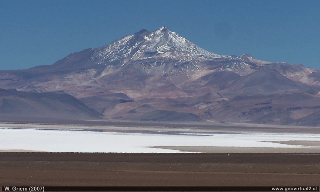
Photo: Maricunga Salt Flat with the Copiapó Volcano in the background. The photo was taken from the north end of the salt flat. The distance to the volcano is still 54 kilometers (about 29 km to the south shore of the salt flat and from there 25 kilometers more. Only during very clear days, without fog, you can enjoy this wonderful panorama.
Height of the shot: 3760 m above sea level. Height of Copiapó Volcano: 6052 meters above sea level. Distance to the volcano: 54 kilometers
(Kodak13290; W. Griem 2007)
more information of the salt flat Maricunga

Description:
Location: Near the High Cordillera, east of Copiapó.
Nearest town: Copiapó (162 km)
Petrol: Copiapó (162 km)
The place: The Maricunga salt lake is located about 3700 meters above sea level. It is an outflowless salt pan, the southernmost in the Chilean Andes. There are no restaurants, overnight accommodations or petrol stations along the route. The police station is located on the eastern shore of the salt lake.
UTM: E493.378 / N70.31.231 - Height: 3758 m. (picture).
more information of the salt flat Maricunga

Information Photo: Kodak Camera DX6490
Focal length: 36,2mm (=218/35mm) | Time: 1:750
F: f/8 | Original size: 2304 x 1728 | Date: 2007/02/22/13:07 hrs.

Map of the area of the salt flat Maricunga at Atacama desert, Chile


Any new publication not authorized by the authors is expressly prohibited. This applies in particular to electronic publications:  Usage guidelines.

previous page of geovirtual, Atacama
Viewpoint content - Content Atacama Region
List of names and places of Atacama
next page in geovirtual, Atacama
line silver en www.geovirtual2.cl

www.geovirtual2.cl
Geology (Spanish)
Apuntes
Apuntes Geología General
Apuntes Geología Estructural
Apuntes Depósitos Minerales
Apuntes Exploraciones Mineras
Geological periods
Literature and Citation
Geological index (spanish)
Virtual museum
Virtual Museum: First page
Geological excursion
Some Minerals
History of Geosciences
Mining in historical literature
Fossils in historical literature
Historical authors mining and geology
Geological index (spanish)
---
Images of Chile and Atacama
---
The Coquimbo Region, Chile
The Coquimbo Region
History of the Coquimbo Region
Railroad history of Coquimbo
Names and places
---
Images from Chile
Atacama Region, Chile
Journey to Atacama
Atacama sightseeing places
History of Atacama
Mining history of Atacama
Geology of Atacama, Chile
The railroad history of Atacama
Flora Atacama
Animals of the Atacama Desert
Virtual viewpoint Atacama
Atacama en b/n
Road - maps /
Morphologic 3-dimensions
Climate history of Atacama
Books & Collection of Books
List of names and places of Atacama
sitemap - list of all files  - schematic content - Information site geovirtual.cl

www.geovirtual2.cl (english) / Virtual Museum / Atacama Region / Viewpoint Atacama
Virtual Museum of Atacama desert and Atacama Region, Chile
© Dr. Wolfgang Griem, Chile - all rights reserved  (Mail a Wolfgang Griem Uso de las páginas de geovirtual.cl y geovirtual2.cl)
Published: 18.11.2017, Updated: 18.11.2017, 27.02.2021
Mail a Wolfgang GriemMail and contact
Ver el perfil de Wolfgang Griem en LinkedInSee perfil Wolfgang Griem
All rights reserved
Any new publication not authorized by the authors is expressly prohibited. This applies in particular to electronic publications: Usage guidelines
© Wolfgang Griem (2005, 2009) - Todos los derechos reservados - alle Rechte vorbehalten - all rights reserved
valido W3C
validated 27.02.2021
HTML/5- R