Atacama virtual: English

www.geovirtual2.cl

Infinite landscapes in the Atacama Desert, Chile

Virtual vantage point to the Desert

Atacama Virtual

W. Griem, 2020

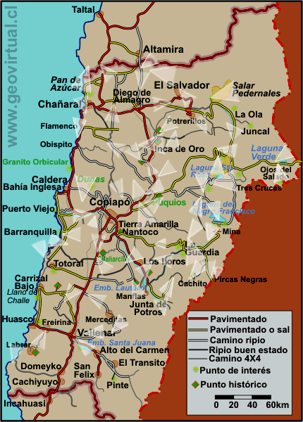
from Llano de Llampos to the snow of the Precordillera view from the Aguilar mine to the SW from Altamira to Doña Inés volcano - Region Atacama (Chile) view of the Los Loros mountain range - Qda. Carrizalillo from the road to Cerro Blanco - Region Atacama (Chile) panoramic view of the Andes Mountains at Cerro Potro - Atacama Region (Chile) from the Chañaral lighthouse to the beach (to the north) - Region Atacama (Chile) Cerro Vicuña from the plains of Quebrada Chañaral Alto - Region Atacama (Chile) see El Salado and the coastal mountain range between Salado and Mina Manto Verde view of El Salvador and Portal del Inca view from the portezuelo El Gato towards the Andes Mountains - Cerro El Potro - Region Atacama (Chile) see Laguna Verde seen to the east - Andes Mountains El Llano de Jaula with the flowery desert - something different - Region Atacama (Chile) the valley of the Rio de la Sal and Llanta - towards Diego de Almagro from Lomas Bayas to the NW - Cerro Blanco sector see a dune in the Atacama Desert - Atacama Region (Chile) The Ojos del Salado in the Andes Mountains of Atacama - Chile Tololo Pampa - an extreme plain - Region Atacama (Chile) Pan Americana in the desert - up to the Doña Inés volcano The Pan Americana between Vallenar and Copiapó - junction to Nantoco - Region Atacama (Chile) see Qda. Paredones and Maricunga mine - Region Atacama (Chile) see Qda. Algarrobal with the road that leads to Merceditas and El Donkey - Region Atacama (Chile) Qda. Salitrosa / Guamanga between Flamenco and Inca de Oro - Region Atacama (Chile) the coastline of Sarco bay La Semilla - Andes Mountains - Atacama Region (Chile) see the plains west of Inca de Oro - in the vicinity of Tres Puntas Vallenar and the Huasco Valley - view to the east - Region Atacama (Chile) Llano de Varas and the Peineta Range The Copiapó volcano from Portezuelo El Gato view from the portezuelo Cachito towards Cerro Anselmo and Jotabeche - Region Atacama (Chile) The Negro Francisco lake in the Atacama desert - Chile The Salar de Maricunga by the descent of the Codocedo portezuelo see Punta Cachitos - Bahía Salada - Region Atacama (Chile) see coast near Pajonales bay - Region Atacama (Chile) see a view of the hills of the Jarrilla - Merceditas sector from the Tabaco pass Road between Vallenar- Qda. Jilguero - Jarilla - Region Atacama (Chile) Llano Leoncito in the sector El Patón - Region Atacama (Chile) Chinches Pass to the north see view of the Totora pass from the mining sanctuary - Region Atacama (Chile) Copiapó River Valley from Piedra Colgada downstream see the Flamenco coast - between Chañaral and Caldera - Region Atacama (Chile) Llano de Varas - road between Copiapó and Inca de Oro see Varas plain - coming down from the Chimberos pass. Inca de Oro - Llano Humito - Sierra Caballo Muerto - Region Atacama (Chile) Dunes between Caldera and Chamonate - a panoramic photo - Region Atacama (Chile) Qda. Carrizalillo - J. Perez - the real desert view of the Pampa Austral plain - Indio Muerto with the Pedro Montt station - Region Atacama (Chile) The viewpoint of Pan de Azúcar National Park - Region Atacama (Chile) Maricunga Salt Flat with Copiapó Volcano in the background Pedernales salt flat in the Atacama desert - Chile view from the portezuelo Pircas Negras towards Cerro Anselmo or Cadillal the snow-capped Jotabecha mountain from the Pircas Negras pass - Region Atacama (Chile) View from Pasto Grande to Potros - Region Atacama (Chile) see the Quebrada Carrizalillo with intense colors of alteration - Region Atacama (Chile) Sierra Peineta with the Chañaral Alto Gorge - Region Atacama (Chile) The Larga creek in the direction of Potrerillos - Region Atacama (Chile) La Ola hill at Maricunga - overwiew to Maricunga plain and the Andes of Atacama Tololo Pampa and Llano of Jaula plain - Atacama desert - Chile to the San Pedro plain towards Cerro Monardes - Copiapó river valley - Region Atacama (Chile) from the Llampos Plain to the Paipote Creek from the Maricunga pass to the Tres Cruces hills - with the Santa Rosa Lagoon - Region Atacama (Chile) View from the Lomas Bayas cemetery towards the Cordillera - Region Atacama (Chile) Atacama: Atacama Desert Virtual Viewpoint - photos of the Atacama Desert

Virtual vantage point to the Atacama Desert:

Completely renovated pages - with high-resolution photos (1100 by 640 pixels), usually bigger than 200 kb. The idea is to show the desert of the Atacama Region with all its contrasts: high mountains versus endless plains; fertile valleys versus sandy areas without traces of life; landscapes without dimensions versus straight lines towards the horizon.


next page of geovirtual, Atacama
Start to Atacama desert


pic infinitos Desiertos
Infinite hills:
From llano of Llampos to the Qda. Paipote
From the Aguilar mine (Puquios) to Qda. Paipote
Llano del Tiro hacia la pre-cordillera (cerro de La Plata)
Lomas Bayas hacia Port. Dadin
Cemetery of  Lomas Bayas to the Andes
Llampos and the  Pre-cordillera with snow
The Sierra Peineta and the ravine of Chañaral Alto
El Salado village and the coast range
Qda. Paredones and the Maricunga mine
Mountains of Merceditas - from the Tabaco pass
Leoncito - El Patón
Chinches pass to Tambaría
Cadillal o Anselmo mountain from Pircas Negras pass

Pic Cordillera
The Andes Mountains:
The highest mountain in Chile: Ojos del Salado
Laguna Verde near of the San Francisco pass
The Tres Cruces mountains
The cerro Potro from el Portezuelo Dadín
The cerro Potro from el Portezuelo El Gato
From Pasto Grande to Potros
The volcan Copiapó from the El Gato pass
Cerro Anselmo and Jotabeche from the Cachito pass
Nevado Jotabeche mountain from Pircas Negras pass
Panoramic view from  La Ola hill to the Llanura Arroyo

pic Llanuras
Infinite plains:
Tololo Pampa and Llano of Jaula plain: A little unusual
The large Guamanga plain nearby Inca de Oro
The Varas plain and the Sierra Peineta mountains near Inca de Oro
The Varas plain nearby Carrera Pinto
The coastal plain near Barranquilla
The San Pedro plain with Monardes hill near Copiapo valley

pic valle
Valleys and ravines:

La Semilla - Junta de Potro
Río de la Sal valley - Llanta, to Diego de Almagro
Road into the  Algarrobal ravine
The Copiapó valley near Piedra Colgada looking downstream
The Carrizalillo ravine east of Maray
The Larga ravine nearby the old mines of Potrerillos

pic costa
Coast and beaches:
Sarco - the southern tip of the Atacama Region
Nearby the fishing village Pajonales between Totoral and Bahía Salado
Punta Cachos - near Bahía Salada
Near Flamenco (between Caldera and Chañaral)
Pan de Azúcar National Park Viewpoint

pic lagunas y salares
Salt flats, lagoons and lakes:
Lagoon Negro Francisco with the mountains Azufre / Vn. Copiapó
Salt flat Maricunga - road from Codocedo pass
Salt flat Maricunga with the Copiapó volcano in the background
The Pedernales salt flat with Doña Inés mountain

pic desierto
Where the desert is really desert:
Pampa Austral and Pampa Indio Muerto with train station
From Altamira to the volcano Doña Inés
The Pan-Americana highway, desert landscape (Qda. Carrizalillo)
Qda. Carrizalillo - and train station J. Pérez near Altamira
Dunes in the vicinity of Copiapó
Near Tres Puntas - plain of Qda. Salitral
Road between Vallenar and Jarilla
Tabaco pass, Los Mortero . Jarilla

pic caminos
Endless roads:
The Pan-Americana highway near Copiapó
Road to Totora pass (road Freirina - Labrar)

Sunset in the desert
Ravine of Chañaral Alto with Vicuña mountain
Llano de Varas - desde la bajada de Chimberos

Something different - the desert
Jaula plain during the flowery desert
Snow at lagoon Santa Rosa with the Tres Cruces mountains

pic pueblos
Cities and Towns:
El Salvador - in the middle of the desert
Vallenar and the Huasco river Valley
From the lighthouse of Chañaral towards the beach
Inca de Oro from the Las Guías mines


Any new publication not authorized by the authors is expressly prohibited. This applies in particular to electronic publications:  Usage guidelines.

previous page of geovirtual, Atacama
Content Atacama Region - Sights in Atacama
List of names and places of Atacama
next page of geovirtual, Atacama
Linea roja en www.geovirtual2.cl

www.geovirtual2.cl
Geology (Spanish)
Apuntes
Apuntes Geología General
Apuntes Geología Estructural
Apuntes Depósitos Minerales
Apuntes Exploraciones Mineras
Geological periods
Literature and Citation
Geological index (spanish)
Virtual museum
Virtual Museum: First page
Geological excursion
Some Minerals
History of Geosciences
Mining in historical literature
Fossils in historical literature
Historical authors mining and geology
Geological index (spanish)
---
Images of Chile and Atacama
---
The Coquimbo Region, Chile
The Coquimbo Region
History of the Coquimbo Region
Railroad history of Coquimbo
Names and places
---
Images from Chile
Atacama Region, Chile
Journey to Atacama
Atacama sightseeing places
History of Atacama
Mining history of Atacama
Geology of Atacama, Chile
The railroad history of Atacama
Flora Atacama
Animals of the Atacama Desert
Virtual viewpoint Atacama
Atacama en b/n
Road - maps /
Morphologic 3-dimensions
Climate history of Atacama
Books & Collection of Books
List of names and places of Atacama
sitemap - list of all files  - schematic content - Information site geovirtual.cl

www.geovirtual2.cl (english) / Virtual Museum / Atacama Region / Viewpoint Atacama
Virtual Museum of Atacama desert and Atacama Region, Chile
© Dr. Wolfgang Griem, Chile - all rights reserved  (Mail a Wolfgang Griem Uso de las páginas de geovirtual.cl y geovirtual2.cl)
Published: 9.07.2008; updated: 19.9.2017, 27.02.2021
Mail a Wolfgang GriemMail and contact
Ver el perfil de Wolfgang Griem en LinkedInSee perfil Wolfgang Griem
All rights reserved
Any new publication not authorized by the authors is expressly prohibited. This applies in particular to electronic publications: Usage guidelines
© Wolfgang Griem (2005, 2009) - Todos los derechos reservados - alle Rechte vorbehalten - all rights reserved
valido W3C
validated 27.02.2021
HTML/5- R