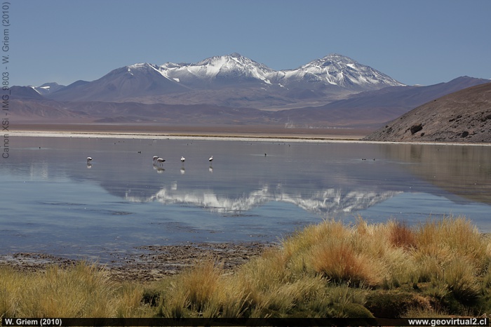
Photo: View of the Santa Rosa lagoon to the east with Nevado Tres Cruces in the background (Atacama Region, Chile). Large photo - (W. Griem, 2010; CaXSi9803)
Information Photo:
Camera Canon XSi | Lente: 50mm | Longitud focal:
50mm | Tiempo: 1:160 | ISO100
F: f/7.1 | Tamaño original: 4272 x 2848 | Fecha:
2010/02/08/11:40hrs.

Lagoon Santa Rosa: p.1 | p.2 | p.3
The Santa Rosa lagoon is one of the most
beautiful excursion destinations in the Atacama region. In calm weather,
the 6700 m high mountains of the Tres Cruces Massif are reflected in the
water of the lake or some flamingos are looking for food.
The Santa Rosa Lake
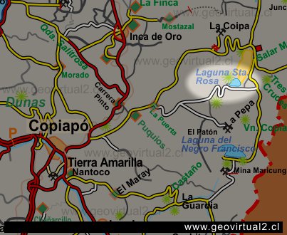
is located 148 km on the road east of Copiapó, in the salt flats
depression of the Atacama Region (Chile). The lake is connected to the
Salar de Maricunga (Maricunga salt flat) and is located in the continuation to the north. The
lagoon has an extension of 2.0 km by 1.2 km.
The Santa Rosa lagoon is known for its large population of flamingos. In
addition, with a bit of luck, you can see guanacos and vicuñas in this
sector.
The Santa Rosa lagoon is located 3762 meters above sea level. To the south side
of the Lagoon, on a adjacent hill there is a small viewpoint with
interesting information about the hills of the area. Access to this
place is only possible with 4X4 vehicles.
To the west shore there is also a small refuge of CONAF and above a hill
you can visit a viewpoint with information about the hills of the
sector.
Information
Santa Rosa Lake
Location of the site: E 482.925 / N 7004.361 (Pr.S.A.1956)
Elevation: 3762 m
Distance to Copiapó: 152,6 km
Travel time to: 2 hrs. 50 min.
Places of interest
Information about Atacama

Intro Camino Internacional
Chulo (km 24,3)
Puquios (km 57,5)
La Baritina (km 67,7)
Empalme La Puerta (km 75,0)
La Puerta (km 81)
El Escorial (Km 86,4)
Vegas Las Juntas (km 123)
Port. Maricunga (km 140)
►
Lag. Santa Rosa
(Km 147)
Llano Ciénaga Red. (km 158)
Qda. Ciénaga Red. (km 207)
Pantanillo (km 216)
Laguna N. Francisco (km 229)
Nearby and more
Maricunga
salt flat
Río Lama
The Andes mountains
Atacama desert
Related pages
Roads of Atacama
Distances between ....
Road
maps
Mining history of Atacama
Tourist
information
Atacama
Travel instructions
Behavior in the desert
Specific terms
The Andes mountains
Atacama desert
Other units
Atacama black and white
Virtual viewpoint Atacama
Collection of Books

