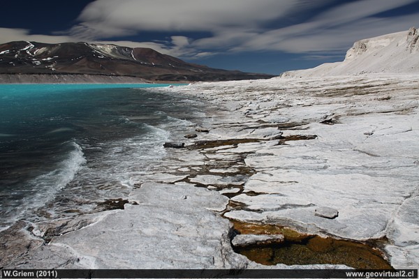
Cordillera de los Andes: Laguna Verde (Green Lagoon) near Paso San
Francisco in the Atacama Region, Chile.
Photo: W. Griem (2011;
Ca50D3300) -
Large Photo
Information Photo:
Camera Canon 50D | Lens:20mm | Focal length: 20mm
+pol. | Shutter speed: 1:400 | ISO100
F: f/5.6 | Original size: 4752 x 3168 | Date:
2010/09/16/14:14hrs.
The Pre Cordillera
- Information:
The "pre-cordillera" of the Andes is located between the longitudinal
valley and the depression of the salt flats with an extension east -
west of 80 to 120 km. Generally the highest mountains reach no more than
5300 m (Co. Bravo Alto). There are some roads in this sector to cross
the pre-cordillera:
Routes to the main mountain range:
a) El Salvador - La Ola (mostly like (b))
b)
Diego de Almagro - Montandon - Pedernales, Maricunga
c)
Qda. Chañaral Alto - Co. La Ola (complicated or cut)
d)
Qda. Paipote - Salar de Maricunga
e)
Qda. Paipote - Laguna Santa Rosa - Negro Francisco
f)
Qda. Carrizalillo - La Guardia - Laguna Negro Francisco
g)
Valle Copiapó - Iglesia Colorada- Semilla o Cachito
h)
Vallenar - Alto del Carmen - San Félix o El Transito
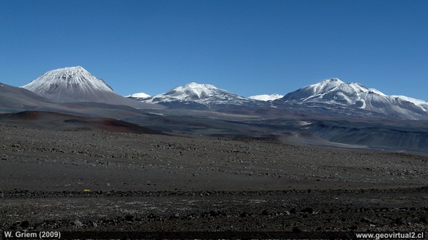
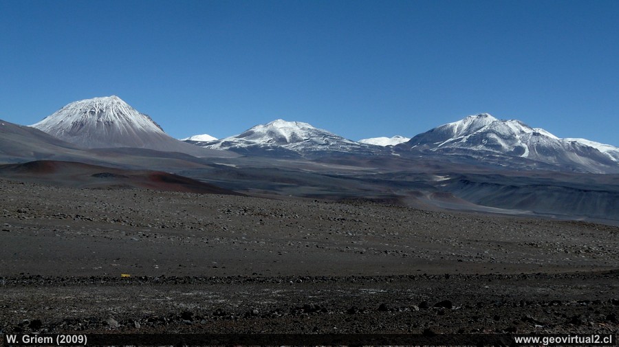
Cordillera principal, from the road to Paso San Francisco (W. Griem, 2009; Panasonic7678) - Large Photo
Information Photo:
Camera Panasonic DMC-FZ18 | Focal length: 9mm | Shutter speed: 1:300 | ISO100
F: f/5.6 | Original size (px): 3264 x 2448 | Date:
2009/03/01/15:36hrs.
Perhaps the most impressive excursion in Atacama leads into the Andean main chain. A series of volcanoes over 6000 m high offer an unforgettable spectacle. When the weather is good, a blue sky opens up, which is hard to find elsewhere.
The Andes' main mountain range is marked in the Atacama
Region by a chain of volcanoes, with maximum heights from 6000 meters to
6893 meters.
The most important passes (San Francisco and Pircas
Negras) reach altitudes of 4723 and 4200 meters above sea level,
respectively. Also, there are extensive plains in this sector, which
show heights between 4200 and 4600 meters. The climate is quite harsh,
and frequent heavy snowfalls characterize winter. The same phenomenon,
but not so frequent, can occur during the summer. The nights are cold,
and the amount of rainfall is much higher than in Copiapó. Also, the
reduced amount of oxygen that produces an inevitable miscarriage may
even be dangerous. Some people do not feel the height, but others suffer
a lot; nausea, headache is the most common symptoms and should be
lowered immediately.
o reach the high cordillera, you first have to go through the
pre-cordillera. The extensive salt lakes and their areas of flattening
are adjoining the pre-cordillera. (In the south of the lagoon "Negro
Francisco," these drainless, endorheic basins are missing.
In the
Atacama region area, about eight routes are leading to or into the main
cordillera. The most comfortable one is undoubtedly the "Camino
International," which also has a particular position because of its
beautiful view and morphological features.
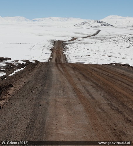
Road from Maricunga to Pedernales in winter - Atacama Region, Chile
Places of interest
Information about Atacama
Atacama
Travel instructions
Behavior in the desert
Specific terms
●
The Andes mountains (I)
The Andes mountains (II)
Atacama desert (1)
Atacama desert (2)
Rains in the Atacama desert
Flowering desert (1)
Flowering desert (2)
Flowering desert (3)
Snow in the Atacama desert (1)
Snow in the Atacama desert (2)
Virtual viewpoint Atacama
Atacama black and white
Road maps of Atacama
Camino Internacional
Portezuelo Maricunga
Salar Maricunga
(engl.)
Santa Rosa lake
Camino a Laguna Verde
Ex. Hostal Muray
Ojos del Salado
(engl.)
Laguna Verde
(engl.)
Co Incahuasi
Desert & Atacama
Journey to Atacama
Rutas en Atacama
Pan-Americana
Distances within Atacama
Road maps of Atacama
Atacama Litarature & Books
Links, enlaces Atacama
Imágenes 3-dimensionales
Atacama landscape
The Atacama desert
Flowering desert
Beaches of Atacama
Las Dunas
de Atacama
Páginas relacionadas
Rutas de Atacama
Distancia entre ....
Mapas
Mining in Atacama
Listado de minas y distritos
History,
Mining, Atacama
Climate of the Atacama Region
Mining in Atacama
El Ferrocarril de Atacama

