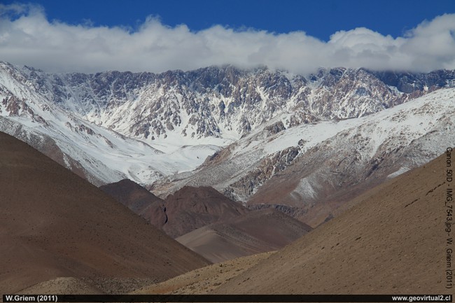
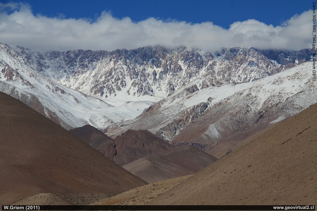
Photo: The Andes Mountains of Atacama in the vicinity of La Semilla:
Cerro Potro.
(W. Griem 2011;
Ca50D7543) -
Large Photo
Information Photo:
Camera Canon 50D | Lens:18-200mm | Focal length:
110mm | Shutter speed: 1:500 | ISO100
F: f/11 | Original size: 4752 x 3168 | Date: 2011/07/13/14:02hrs.
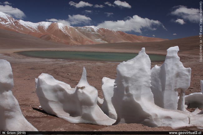
Photo: Penitents in the Atacama mountain range 5000 meters high - Pircas Negras - Casale fence. W. Griem (2010: CaXSi9554): en grande
Information Photo:
Camera Canon XSi | Lens: 20mm +pol | Focal length:
20mm | Shutter speed: 1:160 | ISO100
F: f/8 | Original size: 4272 x 2848 | Date: 2010/02/03/14:58hrs.
| List of peaks over 6000 m elevation in Atacama | |||
| Name | UTM | High | comments |
| Nevados Ojos del Salado | 7002/546 | 6893 | Highest mountain, highest volcano in the world. |
| Nevado Tres Cruces | 7003/522 | 6748 | Large massif very unknown |
| Nevado Tres Cruces | 7006/522 | 6629 | North peak of Tres Cruces |
| Nevado del Incahuasi | 7010/570 | 6621 | West of the Fraile mountain |
| Sin nombre / sur del ODS | 6994/542 | 6510 | unnamed |
| Co. El Muerto | 7008/551 | 6488 | West of Fraile peak |
| Co. de Los Patos o Tres Quebradas | 6981/519 | 6239 | Border to Argentina |
| Cerro Solo | 7002/528 | 6205 | West of ODS |
| Co. Del Toro | 6778/423 | 6188 | Cajón del Encierro |
| El Muerto, satélite | 7006/551 | 6148 | Nearby border to Argentina |
| Co. Ermitaño | 7038/540 | 6146 | isolated, north on the way to Lag. Verde |
| Sierra Nevada | 7070/541 | 6127 | Border to Argentina |
| Sin Nombre / cerca Fraile | 7000/552 | 6120 | South of Co. El Muerto |
| Co's. Barranca Blancas | 7015/533 | 6119 | South of road to Lag. Verde |
| Co. Colorado (Cumbre Negro) | 7105/562 | 6080 | Border to Argentina |
| Cerros Vicuñas | 7011/539 | 6067 | isolated, N' of ODS |
| Co. El Fraile | 7009/561 | 6061 | West to Incahuasi |
| Co. Azufre o Vo. Copiapó | 6980/487 | 6052 | isolated, N' of Lag. Neg. Fran. |
| Macizo Tres Cruces s/n | 7009/518 | 6030 | isolated / the most N' del MTC. |
| Peña Blanca | 7035/536 | 6030 | isolated, N' road to Lag. Verde |
| Co. San Francisco | 7025/573 | 6018 | S' paso San Francisco |
| Sierra Nevada (satelite) | 7072/541 | 6013 | Port. S. Nevada |
| www.geovirtual2.cl | |||
The Andes of Atacama: p.1 | p.2
In the Atacama Region, there are 22 peaks with a height
of more than 6000 meters. (This number is variable according to the
count mode. It is not always clear where a new mountain begins)
The highest peaks in the Atacama Region are the Ojos del Salado with
6893 m above sea level, followed by the Tres Cruces with 6748 m, Macizo
Tres Cruces (6629 m) and Incahuasi with 6621 m. In addition, the Nevado
el Muerto (6488 m), Cerro del Toro (6168 m), Cerro Colorado (6080 m).
Interesting are the isolated mountains that are not part of the
border chain: especially Co. Azufre or Copiapó with its 6052 meters, the
Co. Ermitano with its 6146 meters, the hills of Barrancas Blancas with
6119 meters, Co. Vicuñas (6067m) and Peña Blanca (6030m) stand out for
this phenomenon. In a generalized way, it can be concluded that towards
the south of the region, the main chain's heights are diminished.
For about one hundred years, the main mountain range's real
dimensions in the Atacama sector have been known. Until the 1870s, there
was only a little geographical information. Of course, the excellent
work of Philippi, Bertrand and Burmeister was the first seed in the
discovery of the mountain ranges. But it is also worth mentioning that
there were always roads between Argentina and Chile that crossed the
Atacama sector's mountain ranges. Burmeister describes the use of three
passes, especially by muleteers with their cattle and traders.
Photo information:
During melting snow forms strange figures. The wind and the
direction of the sun make some parts more affected than others. A
labyrinth of sloping ice pillars remains..
Places of interest
Information about Atacama
Atacama
Travel instructions
Behavior in the desert
Specific terms
The Andes mountains (I)
●
The Andes mountains (II)
Atacama desert (1)
Atacama desert (2)
Rains in the Atacama desert
Flowering desert (1)
Flowering desert (2)
Flowering desert (3)
Snow in the Atacama desert (1)
Snow in the Atacama desert (2)
Virtual viewpoint Atacama
Atacama black and white
Road maps of Atacama
Camino Internacional
Portezuelo Maricunga
Maricunga
Laguna Santa Rosa
Camino a Laguna Verde
Ex. Hostal Muray
Laguna Verde
Ojos del Salado
Co Incahuasi
Desert & Atacama
Journey to Atacama
Rutas en Atacama
Pan Americana
Distances within Atacama
Road maps of Atacama
Atacama Literature & Books
Links, enlaces Atacama
Imágenes 3-dimensionales
Atacama landscape
The Atacama desert
El desierto
florido
Beaches of Atacama
Las Dunas
de Atacama
Páginas relacionadas
Rutas de Atacama
Distancia entre ....
Mapas
Mining in Atacama
Listado de minas y distritos
History,
Mining, Atacama
Historia del clima en Atacama
Mining in Atacama
El Ferrocarril de Atacama

