Introduction:
The Atacama Region is noted for its large number of beaches and bays
that are excellent for summer vacations.
Caldera,
Bahía Inglesa, Puerto
Viejo, Barranquilla and
Huasco are the best known
places. But there are also a number of lonely, wild beaches with
inexpressible solitude. These places invite you to observe the marine or
coastal fauna. Especially in the
Pan de Azúcar sector
(National Park) you can observe sea lions, penguins and a great
diversity of birds.
As the Atacama Region is part of the
Atacama
Desert, the
climate is quite
pleasant and the sun accompanies us almost all year round. Only in the
mornings is known the phenomenon of camanchaca, a dense fog that usually
disappears between 10 to 12 hours in the morning.
Start here from Huasco to Pan de Azúcar
The water temperatures on the coast of the Atacama
Region in summer are between 17°C and 20°C. Between October and the end
of March, perhaps until the whole month of April you can enjoy the
warmth and sunshine on the beautiful beaches of the Region. But winter
also has some pleasant days for the beach.
Restaurants exist in Chañaral, Caldera, Bahía Inglesa and Huasco. In
many small fishing villages, fish are offered in small restaurants that
only operate in the summer.
The countless number of beaches along the Atacama coast does not allow
for surveillance in all sectors. Some beaches do not have lifeguards
etc.
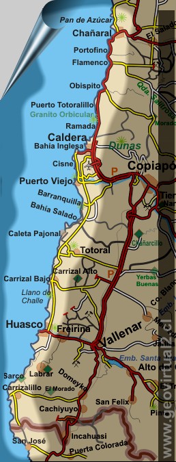
The Coastal Highway of Atacama
| List of places, beaches and coastal areas: | ||
| UTM (N) | Name | Description |
| 71.06.600 | Pan de Azúcar | National park with tourist infrastructure: cabins, restaurants, tourist information, etc. |
| 70.85.600 | Chañaral | Coastal city in the Atacama Region, with an industrial-mining history of several centuries. |
| 70.73.200 | La Cascada | |
| 70.69.600 | Los Médanos | Well rocky coastal area |
| 70.61.300 | Punta Flamenco | |
| 70.15.300 | Granito Orbicular | Special geological formation |
| 70.11.300 | Ramada | |
| 70.05.000 | Caldera | Atacama Region Tourist Centre |
| 70.00.600 | Bahía Inglesa | Tourist center with restaurants, hotels and beaches |
| 69.97.000 | Las Machas, Rocas Negras | |
| 69.95.300 | Parque Paleontológico | Project - Palaeontological Museum |
| 69.88.800 | Chorrillos | |
| 69.86.500 | Bahía Cisne | Beautiful beach without vehicles. |
| 69.82.000 | Isla Chata, Juntas de Agua | |
| 69.76.800 | Mouth of the Copiapo river | |
| 69.74.800 | Puerto Viejo | |
| 69.71.800 | Playa La Virgen | |
| 69.56.500 | Pampa Cachiyuyal | Sunset in the sector near Barranquillas |
| 69.55.000 | Barranquilla | Formerly one of the most beautiful beaches, unfortunately now a waste dump (see at 2012). |
| 69.55.200 | Caleta Barranquilla | Fishing harbour, restaurant, fish |
| 69.41.900 | Bahía El Salado | Wide bay, very beautiful for swimming. |
| 69.35.800 | Punta Cachos | Peninsula |
| 69.30.600 | Caleta Pajonal | Picturesque fishing harbour. |
| 69.21.000 | Dunas, carretera costa | |
| 69.12.200 | Totoral | Beautiful village 20 kms inland |
| 69.11.600 | Sector Gaviotas | |
| 68.95.300 | Qda Higuera | |
| 68.91.700 | Carrizal Bajo | Coastal village between Vallenar and Caldera |
| 68.75.700 | Pta. Molle | |
| 68.49.600 | Huasco | City located on the coast, Atacama Region |
| 68.10.900 | Caleta El Cobre | Ruins of a historic port |
| 68.11.000 | Costa de Sarco | Ruins of a historic port |
| 67.78.300 | Carrizalillo (pueblo) | Village |
| 67.77.200 | Bahía Carrizalillo | |
| 67.62.100 | Caleta Punta de Choros | |
| 67.57.500 | San José | |
| www.geovirtual2.cl / W.Griem 2013 | ||

Beach of Cisne (Atacama desert, Chile); W. Griem
(2006; K8534)
Large photo
Places of interest
Information about Atacama
►
The coast of Atacama
San José
Caleta Punta de Choros
Bahía Carrizalillo
Carrizalillo
Costa de Sarco
Caleta El Cobre
Huasco
Pta. Molle
Carrizal Bajo
Qda Higuera
Sector Gaviotas
Caleta Pajonal
Punta Cachos
Bahía El Salado
Barranquilla
Pampa Cachiyuyal
Playa La Virgen
Puerto Viejo
Isla Chata
Bahía Cisne
Chorrillos
Parque Paleontológico
Rocas Negras /
Las Machas
Bahía Inglesa
Caldera
Ramada
Granito Orbicular
Punta Flamenco
Los Médanos
La Cascada
Chañaral
Pan de Azúcar
Information
desert of
Atacama
Flora del desierto Atacama
Animales del desierto Atacama
Historia de Atacama
Virtual viewpoint Atacama
Vida Atacama en fotos b/n
Mapas de Atacama
Imágenes 3-dimensionales
Historia del clima en Atacama
Mining history of Atacama
Railroad history of Atacama
Atacama landscape
The Atacama desert
El desierto
florido
Beaches of Atacama
Las Dunas
de Atacama
Tourist
information
Atacama
Travel instructions
Behavior in the desert
Specific terms
The Andes mountains
Atacama desert

