Content
Tres Puntas today
Mines of Tres Puntas
Introduction
Historical Resources
---
page +
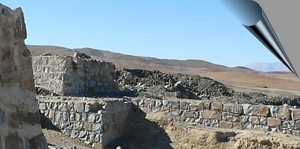
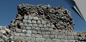
The ruins of Tres Puntas
Map: situation today
The ruins of the Tres Puntas village are on the verge of disappearing, some few visible remains are left in the middle of the desert.
The mines
Buena Esperanza
Cobriza
Al Fin Hallada
There were only a few vestiges of the mining district, some walls,
shafts, pits and stairs lost in the desert.
Complete list of the
mines
Introduction, Tres
Puntas district (Atacama region):
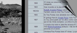
Tres Puntas is probably the second best-known historical mining district
after Chañarcillo (in this case). Located about 80 kilometers away from
Copiapó, actually in the desert. A large number of abandoned mines can
still be seen with the remains of plants and buildings. Some walls and
foundations remained of the mythical village.
Between 1848 and 1922,
the production reached between 20 and 70 tons of fine silver annually.
According to historical descriptions, Tres Puntas could be a western
film model (see:
life in Tres Puntas).
But on the other side of the coin, there
was a highly technical mining operation in this era. In particular,
English printing companies' mines achieved impressive production
quantities (see:
Esperanza mine). Unfortunately, the vein - deposits did not continue
into very high depths. The deeper parts generally show lower ore -
grades, and the mineralization changed.
But the boom period in this
district was not as short as has generally been thought: almost 30 years
after the discovery, fine silver production reached nearly 27 tonnes.
Nowadays, in 2020 we should
note that in those days (between 1895 and 1910), silver as a metal
entered a global crisis. Silver metal prices fell to a historic low and
should not recover in the next few years either. Many mines lost their
profitability forever.
Cemetery
The cemetery of Tres Puntas in the middle of the Atacama Desert
Statistics
General
Tres Puntas 1869
Chimbero 1869
Tres Puntas 1876
Chimbero 1876
Historical maps
Total
Sector Fin Hallada
Sector Victoria
Images of Chile and Atacama
Village Tres Puntas - Philippi
Cancha Tres Puntas - Tornero
Apires at Buena Esperanza (Tornero)
Informative
Chart
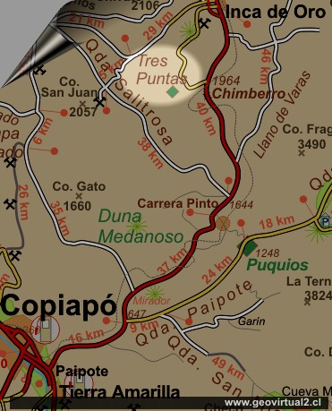
Location: Tres Puntas
Diego de Almagro Communa, Atacama Region
UTM Location: E404.238 / N70.28.231
Altitude: 2013 m
Location: 14 km to SW (straight line) of Inca de Oro.
Road: 96 kms from Copiapó
Status: Abandoned
Mineralization: Ag (silver) in veins
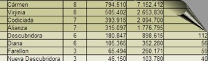
List of all
the mines and owners..
A listing of all historic mines with historical production information
and owners . .

Historical documents
Historical texts
Treutler -
the village of Tres Puntas
Treutler - dancing bar in Tres Puntas
Treutler - Interior de La Salvadora
Treutler - the miners of Tres Puntas
Treutler: Mining at Tres Puntas
Terremoto en Tres Puntas (Treutler)
Treutler accidente en Tres Puntas
San Román:
Geology of Tres Puntas
Carta de un minero de Cornwall
Philippi at Tres Puntas
Philippi: History of Tres Puntas
Philippi: Description of Tres Puntas
Historical sketches
Buena Esperanza mine
Selection of minerals B. Esperanza
Dance Pub at Tres Puntas
Philippi: Tres Puntas 1
Philippi: Tres Puntas details
Interior Mina* (Treutler)
Mining Atacama
Journey to Atacama
español / deutsch / english
Mining Atacama:
Content Mining Atacama
List
of mining districts Atacama
Mining from 1830 to 1920
Chañarcillo
►Tres
Puntas
Cerro Blanco
district
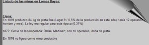
Lomas Bayas
district
Agua Amarga
Inca de Oro
district
Puquios - Carrera Pinto
Cachiyuyo de Llampos
district
Carrizal Alto
Checo de Cobre
More mining districts ...
Surroundings
Inca de Oro (village)
Llano de Varas
Ruta Copiapó - Diego de Almagro
Train station Chimbero
Atacama desert, Tres Puntas
History of mining
Introducing epoch 1830-1920
Technical innovations
Scientific innovations
Social conscience
Educational impulse
Mine safety
Globalization
Others
Railroad history of Atacama
History
of Atacama
Mining history of Atacama
Flora Atacama
Animals of the Atacama Desert
Geología Atacama
Climate of the Atacama Region
Atacama desert
Beaches of Atacama
The Andes mountains
Rutas de Atacama
Carretera Panamericana
Aeródromos en Atacama
Tourist
information
Atacama
Travel instructions
Behavior in the desert
Specific terms
The Andes mountains
Atacama desert