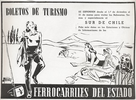
From: Guía Veraneante 1943 (FFCC del Estado Chile)
| Gauges of the railway lines in Atacama | |
| gauges | description |
| 760 mm | The route between the Dulcinea mine plant
and the foundry (located in the Carrera Pinto sector). Historically it corresponds to the "Bosnia trail" very common in parts of Austria, Italy, Hungary, Czech Republic etc.. ... |
| 1000 mm | Current gauge of the
longitudinal path, of the line between
Chañaral and Potrerillos, as well as the
Huasco,
Vallenar and Los Colorados lines, etc. Very common in the countries of South America, but also in Europe (as tram). |
| 1067 mm | The gauge of the laying in the beginning
between
Chañaral - El Salado y Las Animas. "Cape Trail" then South Africa, parts of Australia, Sweden, Norway, Ecuador etc.. |
| 1270 mm | The gauge of the
Carrizal Alto, Carrizal Bajo, Jarrilla, Yerba Buenas, Astillas,
La Negra and Coquimbana routes. It hardly exists in other parts of the world (or?) |
| 1435 mm | In the beginning the line Caldera -
Copiapó, Copiapó - Puquios and Copiapó - San Antonio /
Chañarcillo. It corresponds to the Stephenson standard - very common today in Europe (England, Germany, France...) |
| List of gauges used in Atacama | |
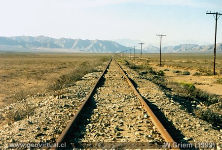
Photo: Appearance of the longitudinal line in
the vicinity of Copiapó in the nineties.
Line between Vallenar and Copiapó near Travesía station. The section was
built between 1913 and 1914 and is part of the longitudinal line between
La Calera and Pintadas. (Foto: Wolfgang Griem; 1999)
History of railways, Atacama: p.1 І p.2 І p.3 І p.4
Historic Railroad
Network in the Atacama Region, Chile
There are still some railway lines in the Atacama Desert. In the
beginning, the 1435 mm gauge was installed, although later the gauge was
changed to 1000 mm. In straight lines of many kilometers the rails get
lost on the horizon. It is a unique contrast: The desert with its
smooth, round morphology - generally curved, not even the horizon is a
horizontal line - in this scene a straight line of the railway
translates as the only support for the human eye to approach the horizon
1.
The routes are not the result of centralised planning, and the
individual lines in particular have served a specific purpose. The main
objectives were, of course, to satisfy the mining companies: the
transport of minerals from the worksite to the port and vice versa the
transport of products (tools, machines, foodstuffs) from the port to the
worksite. Only the longitudinal path makes a difference - here it was a
project to include not only industrial requirements, also the need to
develop the country's infrastructure as well.
Interesting is the use of different gauges on different routes. In the
beginning, the Stephenson standard (1435 mm) was implemented according
to the predominance of English companies in the construction of the
lines. But the Stephenson standard (unhappily) was not without
competition. In Chañaral won the 1067mm gauge and Carrizal's railway
line was left with the 1270mm gauge. Not to mention the internal
railroads in the mines, for example in the Dulcinea mine which had a 760
mm gauge. In order to achieve a better compatibility, the majority of
the trajectories were changed to a single 1000mm gauge.
Another major technical problem was the lack, or poor water quality.
Steam locomotives needed relatively pure water to respect salts,
especially calcium. Solar energy purifiers were installed in parts.
The desert climate also did not help the railway companies' operations:
torrential rains often cut traffic. The planning of the journeys
depended very much on the morphological situation. Large differences in
level, especially the deep ravines, made it difficult to perform. On the
other side there are large plains that allowed the construction of
straight roads without major difficulties.
Notas:
1) The Santiago-Copiapó stretch took three days to complete in the
fifties.
2) The "gauge" is the distance between the two rails of the railway
line. The different trails were the result of strategic thinking in
Europe. On the one hand, military and strategic commercial strategies
with the objective of producing an incompatibility between the different
particular systems.
Railways in Atacama
Atacama virtual
Tourist interest
Content railroad Atacama
Intro 1:
General information
►
Intro 2: Lines and gauges
Intro 3: Map amd tracks
Intro 4:
Map and lines
Listado de todas las líneas
Railways of the north of Chile
Longitudinal Atacama
Longitudinal Coquimbo
Línea Mina Tofo
Línea Carrizal - Yerbas Buenas
Línea Chañarcillo
Línea Chañaral - Animas
Líneas Salitreras (Taltal)
más
●
Registros históricos
●
Trayectos planificados
●
Pictures of railroad
●
Planos históricos, trayectos
More railways
Ferrocarriles Coquimbo
Longitudinal La Calera
Longitudinal Atacama
Línea Mina Tofo
Línea Carrizal - Yerbas Buenas
Línea Chañarcillo
Línea Chañaral - Animas
Líneas Salitreras (Taltal)
Estación Copiapó
Locomotora La Copiapó
Viaje en Tren
Planificaciones Trasandinos
The sector: tourism
Región de Atacama
Lugares turísticos
Historia de la Región
La Panamericana en Atacama
Further
information
Mining history of Atacama
History
of Atacama
Flora Atacama
Animals of the Atacama Desert
Geology
Atacama
Climate of the Atacama Region
The Andes mountains
Atacama desert
Virtual viewpoint Atacama
Aeródromos en Atacama